 Before the first dinosaurs, before the first mammals, just as the very first forests were beginning to form on Earth, the land that makes up New York State today was covered by an ancient ocean.
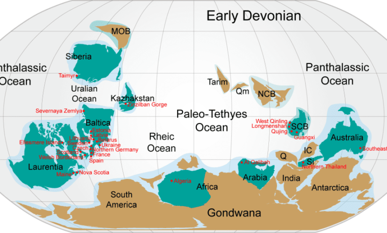
It was a tropical landscape located south of the equator, home to the world’s first true forests, which played a pivotal role in cooling the Earth’s climate by drawing down carbon dioxide.
Massive continental glaciers during the Ice Ages, carved New York’s iconic waterways including the Finger Lakes, Lake George, the Hudson River, and waterfalls like Niagara Falls and the Ithaca Gorges. Glacial deposits formed dams and shaped riverbeds, leaving a legacy of dramatic landscapes and sediment-rich floodplains.
 The Hudson Valley was essentially carved by a massive river of ice flowing south, a precursor to the modern river. As ice melted, immense proglacial lakes like Glacial Lake Albany formed, depositing fine silts and clays, creating fertile floodplains that became important for early settlements.
The Hudson River’s outlet was once blocked by glacial sediment (a moraine), and catastrophic floods later carved the final channel to the Atlantic Ocean.
Manhattan and New York Harbor sit on ancient hard bedrock (schist, gneiss), while glaciers and rivers deposited younger sand, gravel, and clay.
How geology formed by this ancient world, nearly 400 million years ago, shaped life and commerce along the Hudson River throughout the 1800s and into the present will be the subject of of a presentation by the Hudson River Maritime Museum’s Abby Drayer.
This program, on Wednesday, January 14th at 7 pm, is being presented in-person at the Hudson River Maritime Museum’s Wooden Boat School, 86 Rondout Landing, in Kingston, NY. Admission is $10 or $5 for Maritime Museum members. Register here.
For more than a decade the Hudson River Maritime Museum’s “Follow the River Lecture Series” has hosted historians, authors, and maritime experts covering a variety of subjects ranging from regional and maritime history to ecology and art inspired by the river.
Past lectures that were able to be recorded are available to view on the museum’s YouTube channel.
Illustration: World map during the Early Devonian Period, showing continents and terranes with modern continent borders superimposed; and Proglacial and prehistoric lakes of New York and New England during the end of the Wisconsin Glacial Epoch of the Pleistocene Era Glacial Lake Albany, Lake Champlain, Lake Hitchcock, Lake Winsooski, Lake Merrimack.
Source link