 As I kneel digging in the dirt of the gently collapsing stone foundation, birds singing, knees aching, and dirt permanently embedded under my fingernails, I try to imagine life here in Vershire, Vermont, in the 1880s.
I’ve been excavating the bottle caches and midden (trash) heaps of this foundation for three years now, sifting artifacts from the soil. I’m trying to assemble the story of the people who lived here 140 years before me, to anchor myself and my partner within a broader continuity of relationship with this land.
Stone foundations are the less-talked-about cousins of the storied stone walls that trace the landscape. Both are legacies of the glacier that covered all of New England until 13,000 years ago, leaving a layer of till – tumbled-up dirt and stone of every size.
European settlers used these stones for foundations and walls as they cleared the land for subsistence farms in the late 1700s.
Following the introduction of Merino sheep in the early 1810s, New England experienced “Sheep Fever,” with Vermont’s flock alone growing to over 1.7 million by 1840. This led to rapid deforestation, with nearly 80% of the landscape cleared for pasture.
The industry collapsed as wool prices plummeted from 57 cents per pound in 1835 to 25 cents in the late 1840s due to the abolition of protective tariffs and competition from western farmers who could raise sheep at a fraction of the cost ($0.25 vs. $1.00–$2.00 per head in New England).
By the late 1800s, New England experienced a massive exodus of its rural population, leading to farmland.
Still, the traces remain. Each artifact I find adds to the story of this particular spot.
Pieces of oil lamp, harmonica plates, a rusted maple tap, broken tea cups, ball jar lids, and metal buckles of diverse sizes hint at domestic life. The horse and ox shoes and rein guides tell of their farm animals. A silver-plated spoon, gold-gilt buttons, and the rings of two pocket watches say they enjoyed a bit of luxury.
Stamps and embossing show that their beer came from Boston and their whiskey from Kentucky, that they treated their ills with patent medicines from New York, Chicago, and Ohio, that they smoked clay pipes from Scotland, and that they owned china from England.
While these artifacts reveal a lot, placing them in context requires turning to other sources. If you, too, seek to understand the post-settlement history of your land, start with historical maps.
F.W. Beers & Co. produced beautifully detailed county and town maps from the 1850s into the 1880s, capturing the time after the sheep boom but before widespread farm abandonment.
These maps show the locations of roads, houses, farms, orchards, sugar bushes, mills, and more. The foundation on our property is clearly marked as “Beaver Meadow Farm” belonging to C.P. Knight.
You can find images online, and your town or county historical society likely has paper copies, among many other local resources. (New York Almanack has a post about finding local maps here.)
Modern maps can also reveal landscape features; LiDAR, a remote-sensing method, uses laser pulses to create high-resolution topographical maps. These maps reveal protrusions of walls and depressions of foundations.
I found a second foundation this way, way up on the hill at the back edge of our parcel, its L-shaped depression standing out starkly.
I couldn’t find this second foundation on any historical maps, so I met with Gary Goodrich, president of the Vershire Historical Society, to learn more.
I brought a box of artifacts from the hillside foundation. The oldest European settlements in the area were on the high ground, Goodrich told me, along trails made by Indigenous people.
He confirmed what I’d suspected – this second foundation is much older than the first – and identified a previously mysterious metal sphere as part of an ornamental button and a bit of broken blue pottery as English porcelain from between the 1790s and 1820s.
 When the snow is gone for good this season, we have plans to walk the area with a metal detector and see what else we can find. If you have land you’re interested in, take some time to wander there. Follow the stone walls looking for nexuses that served as animal pens.
Walk the landscape looking for unusual shapes, like mounds and depressions. Foundations are sometimes stone-lined, but other times appear only as oddly regular depressions, rectangular or L-shaped, sunk into the earth. You may also find stone-lined well shafts.
Look to the plants for clues, as well. Apple trees don’t occur naturally, nor do lilacs, daylilies, or daffodils. If you find them in the woods, you’ve likely found an old home site.
As the snow disappears from the landscape, the bare ground and emerging vegetation can reveal clues about the past.
Laura J. Costello is a botanist, naturalist, and graduate student in the Field Naturalist Program at the University of Vermont.
The Outside Story is assigned and edited by Northern Woodlands magazine and sponsored by the Wellborn Ecology Fund of New Hampshire Charitable Foundation: nhcf.org.
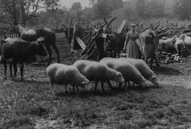
Illustrations, from above: The former Perrin Farm in Massachusetts in the late 19th century; “The Old Farm Yard,” portrait of woman amid cows and sheep by George Barker, ca 1890; and “Atlas of New York and Vicinity, from actual surveys (F.W. Beers, A.D. Ellis, and G.G. Soule, 1867).
Source link