 Simply mentioning “The Adirondacks” can be a great conversation starter, but there are so many Adirondack peaks, lakes, nooks, and crannies that you’ll be asked exactly where in “The Adirondacks” you’re referring to. And, in return, folks will likely have an Adirondack spot of their own to share — fishing the Independence for example, Canada Lake at dawn, a winter view of Moxham Mountain – the possibilities seem infinite.
Their destinations are often places that I have never visited myself so I enjoy finding their variants of “The Adirondacks” on maps and adding them to my growing “to-see” list.
Early Adirondack postcard images interest me in the same way except that they are stubbornly mum; no follow-up questions are allowed. Maps or fellow Adirondackers’ insights usually help but three early postcards were particular mysterious recently — “Lake Golden,” “Along the Shore” and “Ligar’s Lake.”
So, in the spirit of many New York Almanack essays, here is how the locations were discovered, with links to the online resources..
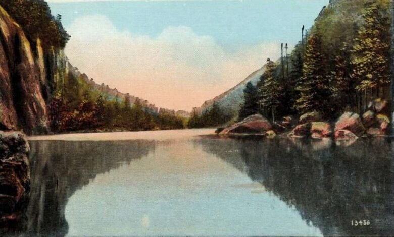
 “Lake Golden, Lake Placid, Adirondacks, N.Y.” (shown above) was published sometime after 1922 by the Miller Art Co., Brooklyn, N.Y. But, unless you immediately recognize the view, forget about finding it by the postcard’s title. There’s no such place.
If it was only a spelling error (i.e. if the title should have been “Lake Colden,” with a “C” not a “G”) that would be confusing enough, but no. It is not an image of Lake Colden either. The view is found upstream from Lake Colden — on Avalanche Lake — which fills the steep defile between Mount Colden, seen on the left in the postcard image, and Avalanche Mountain, on the right.
Photographer Brendan Wiltse captured Avalanche Lake from roughly the same angle. (His online gallery is filled with awesome Adirondack landscapes and incredible light.)
 The postcard “Along the Shore” was published around 1906 by Detroit Photographic Co., which flourished from the late 1890s to the early 1920s. In 1949 the Library of Congress became the repository for thousands of the company’s original glass and film negatives and has since digitized over 25,000 of them.
The original photograph was found there, titled “Concordia Bay, along the shore, Lake George, N.Y.,” and the title thrilled me. When I read it I thought my search was almost complete but no such luck; “Concordia Bay” could not be found on maps of Lake George, historic or otherwise. (Later editions of the postcard include the complete title but, even with that, the mystery remains.)
Further searching in the Library of Congress with “photographs made at Lake George” eventually surfaced another Detroit Photographic image that prominently features and names the same mountain that is in the background of the postcard: Tongue Mountain.
(The Tongue Mountain Range splits the northern end of the lake, deflecting the main body of water northeast from Northwest Bay toward the lake’s outlet — the La Chute River, which flows through Ticonderoga.)
 At this point in the search a three-dimensional, 360º view of a landscape from close to ground level is ideal, and Google Earth does the trick. “Concordia Bay,” if it does exist, seems to be a part of “Huddle Bay” near Bolton, NY.
With the downloaded version of Google Earth you can also place pins and save views on your computer (always save your work before quitting!) After some practice with the downloaded version you can achieve tighter views and mimic the same view of Tongue Mountain that is on the postcard.
By keeping an eye on the view of Tongue Mountain and slowly backing away, the change of view is startling. First, Green Island settles into place on the left side, then nearby Clay Island appears on the right, and then the viewpoint becomes the probable shoreline where the photographer captured the postcard’s view one hundred twenty years earlier.
 Finally, to get a conventional, “bird’s eye view” of this area, typing “Hiawatha Island, Bolton NY” into the search bar of the online USGS National Map brings you right overhead. Each double-click then takes you down closer, giving you an increasing range of labelled details, and a nice map to annotate.
There are also many other base maps and layers to choose from in the upper right corner of the National Map screen, from street maps to satellite images. The entire USGS website is incredibly broad, deep, and detailed.
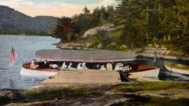
 “Ligar’s Lake, Oswegatchie River in the Adirondacks” was published by The American News Company, NY, in about 1910.
This is such a wonderful view. The lake is quiet and secluded, reminiscent of so many other Adirondack places. And, while it may appear as if nothing is happening here on the shoreline, I suspect that activity has paused only to let someone in the party take the photograph.
There is a makeshift bench with a hat and coat in the lower left corner of the image. The boats hold fishing rods but no oars. The un-tethered boats seem to have been just set down or about to be picked up.
This is surely either the end of an Adirondack “carry” or the beginning of one. (Coming to a lake or going, the shoreline functions the same but people’s expectations are totally different.) If you are a flat water paddler you know these transition moments first hand. You’ve seen this same light on water through the trees; you’ve felt this still, soft air.
At any rate, we’d best keep moving; the rest of the title — “Oswegatchie River in the Adirondacks” — barely narrows things down.
The Internet surfaced one additional clue: “Ligar’s Lake was said to be near the Village of Harrisville, NY.,” which is in Lewis County. Combing the area with early 1900s USGS topographical maps revealed nothing more, but moving back thirty years into the 1870s revived the search.
 Adirondack surveyor Verplanck Colvin drew a fairly complete “sketch map” of the entire Adirondack region in 1873, when he was twenty-six.
His detail of the area around Harrisville logically included good-sized Lake Bonaparte but his addition of a much smaller lake labelled “Cranberry” is curious.
Cranberry seems insignificant at first glance, but the lake has an attribute that Colvin prized highly: it lays on a county line (the Lewis / St. Lawrence County line to be specific), making it a valuable reference point in his surveying (since it could probably be sighted on from other landmarks), and for us too.
Both Lake Bonaparte and tiny Cranberry are in the Town of Diana, and the eminently browsable “Historical and Statistical Gazetteer of New York State 1860” rewards us with a version of the name “Ligar’s Lake” in its description of Diana on page 376:
“Bonaparte and Indian Lakes, in the North part, and Cranberry, Legiers, and Sweets Lakes in the East are the principal bodies of water.”
 With the town and the general locations of the lakes now in hand the rest comes quickly. In the Library of Congress’s online collection of maps the Town of Diana is featured in the 1875 Atlas of Lewis County and on page eleven of this atlas we find the location of our mystery lake solved:
“LeGiers Lake” is the one that lies immediately southwest of Cranberry. [ G “detail page 11 Atlas of Lewis County” here]
And the lake’s current name? Looking at a modern map like the Adirondack Atlas, [ H “detail from Adirondack Atlas map” here] there is only one lake in the eastern section of the Town of Diana that duplicates the placement of “Cranberry” on the county line — today’s “South Creek Lake.”
And we can see that “LeGiers Lake” / a.k.a.“Ligar’s Lake” / today’s “Elijah Lake” is a mile to the southwest of South Creek Lake. Finally, some additional time with Google Earth confirms that the postcard’s image was taken from Elijah Lake’s narrow southwest shore.
 Elijah Lake appears to have no public access though, so please admire it only via maps and early Adirondack postcards, not in person. South Creek Lake, on the other hand, borders the 26,700 acre Aldrich Pond Wild Forest, which also hugs the Lewis / St. Lawrence county line, and the lake appears to have public access from both Harrisville and Pitcairn.
Searching just a bit further, there was no hint of a local person named “LeGairs” or (better yet) “Elijah LeGiers,” but the 1918 Oswegatchie topographical map does show a “Humes Camp” on “Elijah Lake,” and a search of the Humes name in NYS Historic Newspapers surfaced a note in the October 23, 1895 St. Lawrence Republican and Ogdensburgh Weekly Journal newspaper.
That reports that Warren Humes of Harrisville, then age 66, “is the possessor of nine camps scattered about an area of 30,000 acres controlled [i.e. not owned] by himself.” His first camp is located “on the banks of the charming and picturesque Elijah’s Lake.”
(With regards to the spelling of place names “Ogdensburgh” and “Elijah’s,” in 1891 the U.S. Board on Geographical Names officially dropped the final “h” from many place names ending in “burgh,” however the St. Lawrence Republican and Ogdensburgh Weekly Journal kept the original spelling in their masthead. Also at that time, the Board dropped the apostrophe-s from place names such as “Elijah’s Lake.” Which is why the college named Paul Smith’s kept its apostrophe while the hamlet named Paul Smiths did not.)
And then Find A Grave, added that Warren Humes died in 1916, age 86-87, and was buried in Harrisville beside his wife Lucia V. Blanchard Humes (1838-1881). So, during Warren Humes’ lifetime, “LeGairs Lake” was renamed “Elijah’s Lake” and then seemingly nicknamed “Ligar’s Lake” only for the postcard.
Why the 1910 postcard’s title references the pre-1895 name for the lake is still a mystery but it’s a fair guess that Mr. Humes knew the story behind it all.
Obviously another wonderful historical research site is the one you are reading at the moment — John Warren’s New York Almanack of History, Natural History, and the Arts. And the added editorial links in the Almanack’s articles and essays bring many other fine articles and resources to light. Please donate whatever and whenever you can to help keep New York Almanack alive and online!
PS: While trying to put the Ligar’s mystery to rest, another one arose. When you open The State Land Map of the Adirondacks, move west and a little south to the St. Lawrence/Lewis County line, and then zoom into our now-familiar lake that straddles the county line its name reads “South Creek Lake,” but both Google Maps and Apple Maps label it “South Greek Lake” instead (with a “G” not a “C”).
At first that seems to be a familiar spelling error, akin to our earlier Golden / Colden mystery, but apparently it’s not. The U.S. Board on Geographic Names confirms that the official name is indeed “South Greek Lake,” even though the lake’s inlet and its outlet is officially labelled “South Creek.”
Stranger still, if you open the USGS National Map and type “South Greek Lake” into the search bar it delivers you to the only South Greek Lake in the entire nation. This one’s the one.
Thatcher Hogan is the author of the award winning Mapping the Adirondacks: Colvin, Blake, and the First True Survey of the Adirondack Wilderness (2004).
Read more about the Adirondacks.
Illustrations, from above: “Lake Golden, Lake Placid, Adirondacks, N.Y.” post-1922 postcard; Avalanche Pass and Avalanche Lake (courtesy Adirondack Photography by Brendan Wiltse); “Along the Shore,” postcard, ca. 1906, Detroit Photographic Co.; “Along the Shore, Concordia Bay” postcard view from Google Earth; Hiawatha Island, Bolton, NY from the USGS National Map, with arrowing showing direction of the view; “Ligar’s Lake, Oswegatchie River in the Adirondacks” postcard ca. 1910; Detail of 1873 Verplanck Colvin Map; Detail page 11 Atlas of Lewis County showing Ligier’s Lake.
Source link