 Millions of gallons of water are withdrawn for use each day from the lakes, rivers, streams, estuaries and ground waters in New York. To help visualize statewide water use, the New York State Department of Environmental Conservation (DEC) has developed a new Water Use Dashboard, an interactive GIS tool that displays statewide water use data from 2018 to present.
Data are separated by source (groundwater or surface water) and can be further filtered by county and major drainage basin (under the slide to the left).
Water use data is calculated from water usage reports submitted to DEC by water withdrawers with the capacity to withdraw 100,000 gallons per day or more under the Water Withdrawal Reporting program.
Charts outlining total water use by category for reporting years 2018 through 2023 are available on DEC’s website. Find water usage reports for individual facilities on the DEC info Locator under the “Water Withdrawal Annual Reports” layer.
Visit DEC’s Water Use and Conservation webpage for more information on statewide water usage, water conservation tips and manuals, and NYS plumbing fixture requirements.
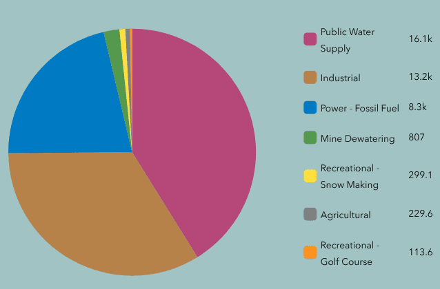
Illustration: Upper Hudson River Watershed Surface Water Use Graph, 2026 (DEC).
Source link