 El Niño is a natural climate pattern characterized by warmer than average sea surface temperatures in the central and eastern equatorial Pacific Ocean, typically returning every two to seven years. It disrupts global weather – and it looks like we may be in for a record El Niño year.
State University at Albany Atmospheric Science Professor Paul Roundy studies how interactions between the tropical ocean and atmosphere influence global weather, including El Niño.
“Normally, the eastern Pacific along the equator is colder than areas to the north and south because steady trade winds pull colder water up from below,” he says. “El Niño occurs when this normal upwelling weakens, leading to warmer-than-average conditions in the usually cool eastern Pacific.”
When the typical “cold tongue” of water nearly disappears, it’s known as a Super El Niño event. Rounday says it’s still too early to say for sure if it will be a Strong or Super El Niño this year, but there are indications that it may be the latter.
The National Oceanic and Atmospheric Administration (NOAA) estimates a 62% chance of El Niño forming by August and persisting through the end of the year.
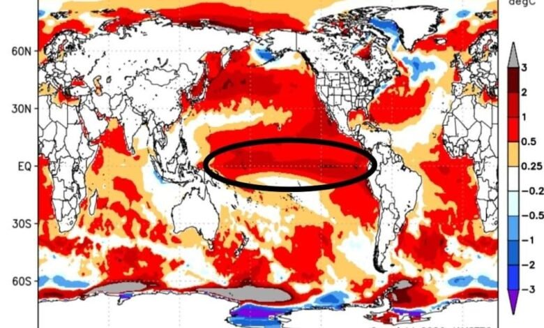
 “A large area of warmer-than-normal water is currently sitting in the west-central equatorial Pacific, and bursts of westerly winds are pushing this warm water eastward. These wind bursts are even stronger than what’s been seen in past spring seasons,” Roundy says.
The last time these effects were this powerful at this time of year, in March 1997, it led to one of the most powerful El Niño events of 20th century.
Some models suggest it could be one of the strongest events in decades, and is developing faster than in 1997 and 1982, based on late-April sea surface temperatures.
The central equatorial Pacific is near 0.8˚C warmer than average, similar to 2015. But unlike past years, subsurface Pacific waters are now locally 7-8˚C above-average.
ENSO predictions from various global models indicate that El Niño will begin in May and reach its maximum in September.
The increased chance of a Super El Niño this year could mean significant warming of global surface temperatures, potentially making 2027 the warmest year on record.
“Prepare for the worst-case scenario,” says Dr. Erma Yulihastin, a climatologist and expert on extreme climate and weather at the Research Center for Climate and Atmosphere in Indonesia.
 There may be heavier rainfall and potential flooding in the Southern United States and a weaker Atlantic hurricane season (though higher risks for the Central and Eastern Pacific).
Although New Yorkers might expect a hotter than average summer with a mix of heat waves and severe thunderstorms, Strong El Niño years also typically lead to unseasonably warm winters.
For example, during the strong 2015-16 event, Albany saw a high of 72°F on Christmas Eve.
A warmer winter would naturally suppress the amount of snowfall for the interior Northeast, but it can also set the stage for major coastal storms and statistically, large snowstorms are more likely during El Niño winters.
We could see fewer small snow events but one or two massive nor’easters that provide most of the season’s total snowfall.
For example, past strong El Niño years like 1982-83 saw record-breaking January storms in New York State.
Read about the impacts of Climate Change.
Illustrations, from above: El Niño–Southern Oscillation predictions from various global models show early and strong El Nino development; April 2026 sea temperature anomalies; and a map showing the difference from average snowfall in inches during El Nino winters from 1959-2023.
Source link