 A canoeist paddling toward the center of Middle Saranac Lake can still hear the dull, monotonous roar of car and truck traffic. Are there any places left in the Adirondacks that could still be considered remote, far removed from the sounds and sights of urbanized America? And if so, how many?
That is what a group of environmental protection organizations – the Adirondack Council, Adirondack Wild, Adirondack Wilderness Advocates and the Rewilding Institute – hope the Adirondack Park Agency and the Department of Environmental Conservation can determine.
Earlier this spring, the group formally asked the state agencies “to develop new policy and guidance to measure… remoteness in the Adirondack Park.”
“The rationale is simple,” said AWA Board Chair Pete Nelson. “If we can measure remoteness, we can better protect it.” Nelson added, “Lands that are remote from human disturbance
are in scarce supply, not only in the United States but even in the Adirondack Park.”
Or, as John Davis of the Rewilding Institute puts it, “the Adirondack Park is the wildest landscape in the east, and yet, it is not yet wild enough.”
Remoteness and the 1972 State Land Master Plan
The term “remoteness” can be found in the State Land Master Plan (SLMP) for the Adirondack Park, which was adopted by the New York State legislature in 1972. The geographers, ecologists and land use experts who crafted the plan ascribed “remoteness” to Forest Preserve lands which would become classified as “wilderness.”
They also used the word to convey aesthetic and spiritual values we associate with wilderness, such as the absence of a human presence and a lack of interference with the ongoing processes of nature.
As David Gibson, a founder of Adirondack Wild says, “Untrammeled Forest Preserve lands contribute to feelings of being unconfined, unlimited and free to explore on foot or ski
remote Adirondack country on its terms, contrasting with our otherwise mechanized and digital lives”
However, the SLMP offers no rigorous definition of “remoteness;” nor does it explicitly categorize the plan’s wilderness, primitive and canoe areas as “remote.” That is a defect which the organizations submitting the request to the APA and the DEC hope to remedy.
“To protect remoteness, we have to measure it and we have to understand its value,” said Jackie Bowen, the Director of Conservation for the Adirondack Council.
Ecological Importance
The Adirondack Council’s Jackie Bowen thinks criteria developed by the U.S. Forest Service to measure remoteness could, at the very least, inform efforts to measure and protect remoteness in the Adirondack Park.
Remoteness as defined by the federal government and some states, for example, is attributed to areas located more than three miles from any road or trail where motorized vehicles are permitted. Other criteria might include dark skies and quiet waters, which is to say, an absence of light pollution and the distant whine of motorboats and jet skis.
According to Bowen, remoteness is of value not only to human beings but to nature itself. “The science about the ecological and biological significance of remoteness is growing,” she said, noting that “Science has demonstrated that remoteness plays a key role in maintaining biodiversity and ecosystem resilience.”
Bowen added, “When roads and trails expand into previously undisturbed areas, the impacts ripple outward, altering wildlife behavior, increasing pressure from invasive species, which
are introduced via recreational activities, and weakening natural climate defenses.”
Among other things, protecting remote areas from any type of disturbance or intrusion – from snowmobiles to the ambient noise of distant traffic – eases the ability of wildlife to move freely across intact landscapes, a necessity for some species as they respond to climate change.
A Management Tool
According to Bowen, “Establishing consistent, science-based measures of remoteness will give managers the tools they need to evaluate those impacts on remoteness and make better long-term decisions on the Forest Preserve.”
For instance, a “science-based” method of determining remoteness might help the APA and the DEC assess the costs and benefits of rerouting or closing roads and trails or of permitting
new recreational activities, such as mountain biking.
“This could be an especially helpful guide when planning choices about where to route hiking, biking, skiing and snowmobiling trails,” said Adirondack Wild’s David Gibson. “By being measurable, this policy can strengthen the contrast value of more remote Forest Preserve lands with areas closer to roads.”
A Public Process
According to a press release from the group of organizations, the APA is being asked to formally consider adopting a “policy and guidance on measuring remoteness” through a public process, one that would include public hearings and a comment period, which would be completed in 2026.
“We will be arranging a meeting with the Adirondack Park Agency within the next two months to discuss this proposal in greater depth,” said Pete Nelson.
Read more about the Adirondack Park.
A version of this article first appeared on the Lake George Mirror, America’s oldest resort paper, covering Lake George and its surrounding environs. You can subscribe to the Mirror HERE.
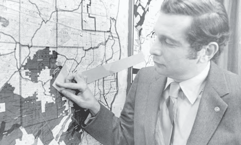
Illustration: A 1972 Lake George Mirror file photo shows DEC Commissioner Henry Diamond directing attention to an area classified as “Wilderness,” four miles from Lake Placid, on the State Land Master Plan map. The plan was adopted by the state legislature earlier that year.
Source link