 The NYS Department of Environmental Conservation’s (DEC) latest episode of the bi-weekly podcast “DEC Does What?!” spotlights the work of the department’s forestry staff who manage the boundaries of state lands.
They discuss the history of land surveying and the man who started the process in the 1800s, Verplanck Colvin (1847–1920).
Colvin was an American lawyer, topographical engineer, and pioneering conservationist whose monumental 28-year survey of Northern New York directly led to the creation of the Adirondack Park and the New York State Forest Preserve.
Often considered the Adirondack equivalent of Western explorer John Wesley Powell, Colvin combined scientific mastery with a deep passion for wilderness preservation.
He pitched, secured funding for, and led the first comprehensive, highly accurate scientific survey of the Adirondack region from 1872 to 1900.
In 1872, Colvin identified and named Lake Tear of the Clouds, the high-altitude pond on Mount Marcy as the highest pool feeding the Hudson River, mapping the true source of the river.
Hosts DEC Chief of Staff and Deputy Commissioner for Equity and Justice Adriana Espinoza and Region 4 Director Sean Mahar talk with Kaleb Winters, Land Surveyor in DEC’s Division of Lands and Forests.
All episodes of “DEC Does What?!” are available on Apple Podcasts, Spotify, YouTube, Am
Read more about Verplanck Colvin.
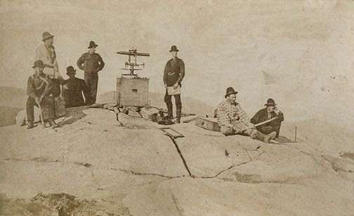
Illustration: Colvin’s Adirondack Survey at work (courtesy Crown Point Historic Site).
Source link